

Thousands of diseased ash trees on private and public land have been identified as in need of removal due to safety concerns, particularly around highways. An interactive map has been created to help landowners understand if they need to take action.
The trees are infected with ash dieback disease or showing other defects, and if not removed they are at risk of collapsing on to roads, causing disruption and potential harm.
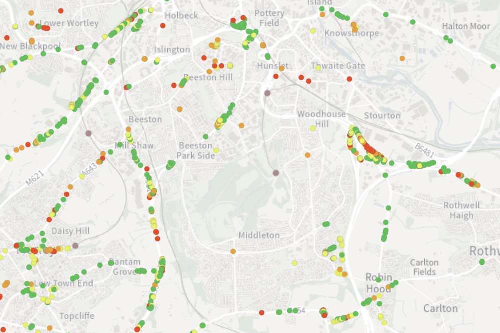
The council has used AI technology to locate ash trees along the highways, and their condition has then been assessed by staff on the ground.
Several hundred trees have already been safely removed and Leeds City Council plans to plant five trees for each one that is removed on council land.
The council has a duty to ensure that no trees under its control put people or property at unreasonable risk. The same applies to private landowners and trees on their land.
Details of identified ash trees near a highway, including their condition and any recommended actions are now accessible to the public through an interactive map on the council website.
A dedicated web page also includes general information and guidance to help private landowners understand if they have affected trees on their land, even if they are not located near to a highway, what their legal responsibilities are and who they can contact for more support.
The fungal disease, which blocks water and nutrient transport, can rapidly weaken trees, leaving them brittle and susceptible to secondary infections, and will significantly alter the UK’s landscape and biodiversity.
Currently there are around 1,300 privately owned trees that require pruning or removal. Another 1,000 are on council-owned land and plans are in place to remove these.
The ash tree survey is ongoing and the map is being continuously updated.
Councillor Mohammed Rafique, Leeds City Council’s executive member for climate, energy, environment and green space, said:
“Ash dieback disease is unfortunately estimated to kill up to 80% to 90% of all ash trees in the UK. In Leeds, our teams have worked hard to identify thousands of trees near to highways that are currently in need of felling.
“Landowners do have responsibility to manage trees on their own land. If you own land near to the highway then you should check the map to view the condition of your trees, but wherever you live it’s also important to read the guidance on the webpage if you are at all concerned about any trees you have on your property.
“The council also has plans in place to remove all trees on our land considered unsafe to remain as they can pose a risk to people and property.”
The website for more information can be found here. The interactive map can be viewed here.
This post is based on a press release issued by Leeds City Council
Image: Interactive map showing affected trees
While you’re here, can we ask a favour?
South Leeds Life is published by a not-for-profit social enterprise. We keep our costs as low as possible but we’ve been hit by increases in the print costs for our monthly newspaper which have doubled in the last two years.
Could you help support local community news by making a one off donation, or even better taking out a supporters subscription?
Donate here, or sign up for a subscription at bit.ly/SLLsubscribe
